Okay folks, I am going to be traveling out West tomorrow and will be gone for awhile. Not sure if I'll be able to squeeze any updates in or not while I am away as internet access may be a bit sketchy. I haven't done a good job on following up on the Indonesian tsunami, and several other short articles have been put on the back burner for the time being, but packing and getting the house into order took a little precedence.
When I get back I am hoping to have some interesting things to share with you, hopefully all of you will stick around for that. If you haven't yet, consider following this blog's rss feed or signing up for the daily email reminder so you'll be informed when I get things rolling again.
See you all on the flip-side,
The Lazy Geographer

A little bit of whatever the world has to offer
Thursday, October 28, 2010
Megasized Loads for Alberta's Oil Sands turns into Fight in Idaho
 |
| Proposed route |
The two oil companies are looking to move giant oil extraction modules to the location of the proposed oil sands mine where production is likely to begin in 2012. To reach the mining site, the modules, 207 in number, will leave South Korea where they have been manufactured, and be transported to the port of Vancouver. From there they will be taken by barge up the Columbia and Snake Rivers to the ports of the western Idaho city of Lewiston. In Lewiston, the equipment would be loaded onto specialized trucks, Self Propelled Modular Transporters (SPMT). The convoy of the 210-foot long juggernaut SPMT and its escort – three pilot cars and two police cars – would travel at night along the 134-miles of US 12 in Idaho and enter Montana at the summit of Lolo Pass on the third night. With top speeds of 35 mph, the 510-mile trip between Lewiston and the Canadian border would take one of the truck convoys nine nights to complete.
While the legalities have yet to be hammered out, ExxonMobile already started to ship its megaloads to the Port of Lewiston in advance of gaining any permits from Idaho or Montana.
Wednesday, October 27, 2010
Dozens Dead in Merapi Eruption; Graphic Video Shows Devastation
 | ||
| Kinahrejo village covered in ash following the eruption of Mount Merapi, Indonesia |
Evacuations continue as many houses have been destroyed by volcanic debris, and the ruins covered in a thick coating of ash. Men have tended to stay behind in the many villages flanking the volcano to maintain livestock and protect possessions while sending women, elderly, and children to shelters further away from the volcano. The villagers have been told to not return during a current lull in volcanic activity, however many have ignored these warning and returned to their homes for fear of loosing their crops and animals.
Tuesday, October 26, 2010
Midwestern Pressure System Sets New Low; Ruins my Day
 |
| ♫ I don't know where I'ma going to go when the low pressure blows! ♫ |
The center of the storm is off to the northwest of me, and our local barometer is reading 979.68 mb. The wind is howling, rain is coming down in sheets, and I need to walk the dog still. Ugh.
Update: Walked the dog. So at least that is out of the way.
Are you getting slammed by this storm? Is the weather ruining your day? If so consider the comment section open for our own private pity party.
NASA Earth Observatory Earthquake Map

7.7 Earthquake Triggers Tsunami in Indonesia; Hundreds Missing, Dead

Monday, October 25, 2010
Indonesia to Evacuate Thousands as Major Volcanic Eruption Looms

Mount Merapi, in central Java, Indonesia, erupted several times on Monday afternoon, with lava spewing down the volcano's southern and southeastern slopes. Three major eruptions were recorded, and other eruptions may have occurred, but thick clouds were obstructing observations of the mountain. Additionally, some 500 volcanic earthquakes have been recorded on the mountain over the weekend.
New Web-Tool for Dietary Friendly Trick'r Treating
A much better GeoBlog than mine, Geographic Travels, brought this villainy to my attention:
And, if not every household has an acceptable candy, and you (do I have readers that go out trick or treating?) or your kid trick or treats with a group, encourage candy trading once you are done canvassing the neighborhood for the night. Candy swapping is an age-old Halloween tradition, and it certainly beats getting stuck with a bunch of candies you don't like or can't eat.
Is this a web tool you could see yourself using?
Oh, and here are some candy ideas for those with a couple dietary restrictions:
Gluten free: Charms Blow Pops, Necco wafers, Tootsie Rolls, BabyRuth
Vegan: Charms Blow Pops, Dum-Dums, Jolly Ranchers hard candy, Pez, Sour Patch Kids, Airheads Taffy
Ghosts, monsters, vampires, werewolves, and zombies will walk the streets this Halloween (fortunately only hunting for candy). There is a real fear for many families, though. Children suffering from medically-necessitated dietary restrictions are at risk of severe reactions to foods with items like nuts, gluten, and high levels of sugar. There are also many more children who have voluntary restrictions like kosher, vegan, and organic diets.On the surface, wanting to avoid candies that may cause an allergic reaction sounds pretty good, but I don't see this as being that practical. The vegan/vegetarian thing I'm not as concerned about because that is a choice. That being said, would you drive clear across town so your kid could hit the one house in your town listed on the site that is giving out sugar-free/dairy-free/gluten-free candies? A better idea would be for parents to brush up on their candy/treat knowledge so they know what their kids can have, and encourage, locally, for households to carry a variety of candies so that their kid can ask for a specific type of candy when they hit a door.
This is a potential Google Maps mashup that can help save Halloween for these children. No Trick Treats allows users to search for and place locations that will be handing out vegan, organic, raw, fruits/vegetables, nut-free, kosher, sugar-free, gluten-free, and non-food goods. There are a limited amount of locations so far but hopefully press coverage of the site will encourage more people to use it.
A vegan Halloween... what a scary thought.
And, if not every household has an acceptable candy, and you (do I have readers that go out trick or treating?) or your kid trick or treats with a group, encourage candy trading once you are done canvassing the neighborhood for the night. Candy swapping is an age-old Halloween tradition, and it certainly beats getting stuck with a bunch of candies you don't like or can't eat.
Is this a web tool you could see yourself using?
Oh, and here are some candy ideas for those with a couple dietary restrictions:
Gluten free: Charms Blow Pops, Necco wafers, Tootsie Rolls, BabyRuth
Vegan: Charms Blow Pops, Dum-Dums, Jolly Ranchers hard candy, Pez, Sour Patch Kids, Airheads Taffy
Saturday, October 23, 2010
Traceability Feature Added to Silk Brand Soymilk
Knowing where your food comes from has become a very trendy thing of late, and the "Buy Local" movement, which has garnered much media attention, is certainly part of the reason. Even Wal-Mart is looking to try and double sales of fresh produce from local farms in its stores by the end of 2015 Other companies are also looking to bump up their street cred with consumers who are increasingly concerned about where their food is coming from.
One company, Silk, which produces soy milk and tofu products, is one of those companies looking to make certain it's consumers know about its initiative to buy only Soybeans sourced in the United States. In an earlier blog post on the subject I noted that Silk had ceased using Chinese soybeans in 2006, but as that post noted, rumors that it still uses soybeans grown in China are still floating around. On top of that, Silk has been trying to put down rumors that genetically modified (GMO) soybeans slip in through the production chain. In order to combat these rumors, Silk has launched a new web-based traceability feature that will allow consumers to find out the counties of origin of the soybeans that went into their carton of soy milk. Silk has also provided a map of farm locations where the soybeans they use are grown.
 Additionally, just before the launch of it's traceability website Silk also enrolled in the Non-GMO Project's Product Verification Program in August. The Non-GMO Project provides an independent third-party test to determine whether a product has met defined standards for the absence of GMOs. While Silk has been doing it's own internal tests since 1996 to try and exclude GMO soybeans, verification with Non-GMO Project allows them to place the Project's verification seal on its packaging.
Several other soy milk and alternative dairy producers, such as WestSoy, Wild Wood, and Organic Valley, also use the Non-GMO Project's seal on their products.
One company, Silk, which produces soy milk and tofu products, is one of those companies looking to make certain it's consumers know about its initiative to buy only Soybeans sourced in the United States. In an earlier blog post on the subject I noted that Silk had ceased using Chinese soybeans in 2006, but as that post noted, rumors that it still uses soybeans grown in China are still floating around. On top of that, Silk has been trying to put down rumors that genetically modified (GMO) soybeans slip in through the production chain. In order to combat these rumors, Silk has launched a new web-based traceability feature that will allow consumers to find out the counties of origin of the soybeans that went into their carton of soy milk. Silk has also provided a map of farm locations where the soybeans they use are grown.

Several other soy milk and alternative dairy producers, such as WestSoy, Wild Wood, and Organic Valley, also use the Non-GMO Project's seal on their products.
Thursday, October 21, 2010
Laminar Flow Demonstration
From Steve Spangler's website:
"What's happening here is very low Reynold's number laminar flow, which means that there are many parallel layers of "sticky" (or viscous) fluid. As the handle is turned, the dyes remain within their original layers and do not mix with each other, even as they are spread out over their individual layers. As the crank is turned backwards, the process is inverted, and since there is no fluid turbulence in laminar flow, the process can be inverted almost perfectly."The Reynold's number is the relationship between viscosity and velocity. As we increase velocity, the Reynold’s number increases and we get a more turbulent flow. Additionally, at the same velocity, the more viscous a fluid is the smaller the Reynold’s number becomes, and if low enough a slow, steady, and laminar flow is created.
Below is a video example of laminar flow of water in a stream. At a very low velocity water will flow in a stream as smooth sheets running parallel to the stream bed. If you could look at the speed of the flow in profile it would have an appearance much like that of a deck of cards with the top card jutting forward over those below. This occurs because the tug of the channel bottom slows the water near the bed while the water layers nearer the surface flow somewhat faster. The intensity of the flow is also so slow that the water has a very low sediment load as only the finest particles can be detached from the bed of the stream, further reducing friction.
If the velocity of the flow were to increase, the friction between the flowing water and the bed would rise. Sediment load would also increase as the water would be able to pick-up or move increasingly larger grains of sediment from the bed. As such, the Reynold's number would also increase, and eventually the flow would become turbulent, the drag creating eddies that would disrupt the water layers above the bed.
However, because water is not very viscous, in nature, conditions for laminar flow are not as common as those that cause turbulence. As such water is is mostly found in states of turbulence.
However, because water is not very viscous, in nature, conditions for laminar flow are not as common as those that cause turbulence. As such water is is mostly found in states of turbulence.
Tuesday, October 19, 2010
Fiji Loses Document Confirming Independence

Fiji is a cluster of 332 islands and 550 islets in Melanesia, east of Australia, and northeast of New Zealand's North Island. 110 of the islands are permanently inhabited, though nearly 87% of the population of 850,000 people reside on the largest two islands of Viti Levu and Vanua Levu.
Britain made Fiji a subject colony in 1874 and went about establishing sugar plantations. Surprisingly, the first governor of Fiji made a policy that disallowed the use of native laborers or interference with the local culture. As a result, Indian contract laborers were brought in to work the plantations instead.
 |
| Sunshine Coast, Viti Levu, Fiji, Melanesia (Source) |
With such a turbulent history since its 1970 independence it is not surprising that the document granting it independence has been misplaced or lost entirely. However, regardless of the lack of any documents, which are largely symbolic, Fiji will remain a independent nation and would not have to revert back to a colony under the UK.
Monday, October 18, 2010
GeoSweep: the UK's Geography-based Lottery
Gambling has been given a new face and technological twist with the recent launch of a new lottery in the UK: the location-based game, GeoSweep, which combines Google Maps with a cash lottery.
The game lets players "buy" locations, called “Geos” in the game, represented on a satellite map of the UK. Each Geo has a cost of £3 for an ownership period of 30 days, and includes a stake for the chance to win £1 million. Once purchased, the player can give their Geos a name or some other identification. Additionally you can share the reason you bought that plot. Is it a lucky place? Is it the house where you were born? Well, you can explain your reasoning behind your lot purchase with a short note.
Two daily draws select winners from those who have purchased Geos. The first drawing has a guaranteed minimum prize pot of £5,000 while the second is the chance to win £1,000,000. The biggest draw for lottery players also may be that the odds are supposed to be 233 percent better than the National Lottery.
Prize zones are selected randomly using quantum optics. For the daily guarantied draw, an occupied Geo is selected at random and then a zone is expanded around it until 100 Geos are selected, occupied or not. The Geo that was selected as the center of the zone wins the main prize and all those occupied Geos surrounding it within the selected zone win secondary prizes. The main £1 million prize is also selected in the same random fashion, though this time an unoccupied Geo may be selected. Once that Geo is selected, again a zone of 100 Geos is created around it. If the central Geo is occupied, the owner gets the £1 million prize. All occupied Geos within the zone get smaller secondary prizes.
It will be curious to watch this game, because I can honestly see turf wars breaking out as residents attempt to control the Geos that rest over their towns, as well as taking over surrounding neighborhoods if given the chance. In that regard, GeoSweep's subscription model should provide a strong income source to maintain the lottery.
If this game were to come to the States, or your country would you play it? I'm not one who is big on gambling, but the geography aspect of this makes it a little more interesting to me.
Friday, October 15, 2010
earthcurrent.com is go
Despite owning the domain since 2003 I'm just now getting something official moved onto the earthcurrent.com domain. Blogspot should automatically redirect you to the new address, so no real need to update bookmarks, RSS feeds, or the like. Big thanks to Chris the Computer Guy at Smarthostplan.com for doing all of the behind-the-scenes tinkering to make the move possible.
Mini-Volcano to be Destroyed 9 Months After First Erupting in St. Helens, Oregon

The volcano fountain, along with an accompanying sign, were meant to draw attention to the touristy shops and restaurants of the town's riverfront, but immediately the installation was decried as an eyesore and safety hazard. Additionally, many were critical of the fact that in the rush to utilize state grant money the volcano bypassed getting a formal OK from either St. Helens' arts commission or its city council, and there was hardly any chance for the public to give input. Now, less than a year later, it has been decided to tear the volcano down.
Built in 2009, the mini-volcano was paid for with about $15,000 from an Oregon Department of Transportation grant and an additional $1,400 in matching city funds that was part of the conditions of the grant. Initially, the volcano would erupt water from its summit at regular intervals, but the fountain eventually began malfunctioning. There were also complaints about teenagers dropping rocks, goldfish, and other things down into the volcano, which were blasted out by the force of the water when it erupted.
The town was divided: some liked the volcano; some hated it, calling it ugly; and some cared less either way. But at a recent forum of the City Council members voted unanimously to remove the fountain following the recomendation of the arts commision.
The most popular outcome from the removal of the volcano would be to replace it with something that would go through a more formal review and approval process with the involvement of the art commission and city council. However, doing so would mean that the $14,000 in grant money used to pay for the bulk of the project would have essentially gone to waste. Also, one of the purposes of the grant was tied to the creation of an artistic sign, so, in order to fulfill the conditions of the grant, the city may forced into replace the volcano with something that has the same price tag affixed to it, but this time all the money would have to come from the town's coffers. This would mean absorbing the cost to dismantle the fountain and surrounding garden, and another $14,000 to replace it. One member of the arts council proposed making a fundraiser out of the demolition. “We should make an event out of it,” she said.
Currently there is no timeline for the volcano to come down. The next step would be to perform a safety evaluation of the corner and intersection where the volcano is located in order to decide what should replace the fountain once it is removed.
Sources:
http://www.spotlightnews.net/news/story.php?story_id=128699996989512800
http://www.spotlightnews.net/news/story.php?story_id=128336661974313900
http://www.spotlightnews.net/news/story.php?story_id=128639938315557900
Thursday, October 14, 2010
Texas County Confuses Flag of Chile for that of their own State

After the mistake was pointed out, the elections administrator in Atascosa County, Janice Ruple, was quick to put the blame on her predecessor. "I don't think it's funny. It's a serious thing," she declared, perhaps chagrined that she hadn't noticed the mistake either in the three years she had held her office.
Now, I should be kind and point out that Chile's and Texas' flags are somewhat similar. They both share the same coloration: red, white, and blue; both have a red bar on the bottom half of the flag; and both have a white star in the middle of a blue field. So mistakenly confusing one for the other is understandable. But in Texas itself? I know of few other states where the citizenry are so into their flag, so the mistake really is surprising.
 |
| State Flag of Texas |
 |
| Flag of Chile |
(Source)
Wednesday, October 13, 2010
Video: 600th Birthday Celebration for Prague's Astronomical Clock
 |
| The Orloj astronomical clock |
To celebrate it's 600th birthday visitors to Old Town Square were entertained with a 10 minute large-screen video of special effects, and visuals of some of the history that the clock has lived through that were projected directly onto the face of Orloj.
Through careful measurements, the video projection managed to create strange and truly amazing optical illusions: such as the outer walls of the clock bulging outward, or opening up to reveal the clockwork mechanisms inside, or cascades of rain pouring down off of the eves of the clock..
For the video and a little bit more on the Orloj clock follow the jump.
Tuesday, October 12, 2010
New Satellite Images of Toxic Hungarian Spill
NASA Earth Observatory has released satellite images of the red mud spill that occurred in Hungary on the 4th of September. The images were taken on the 9th by the Advanced Land Imager on NASA’s Earth Observing-1 satellite.
The first image is a close up of the alumina plant and nearby villages. The portion of the retaining wall that failed is clearly visible in the northwest corner of the waste reservoir.
The first image is a close up of the alumina plant and nearby villages. The portion of the retaining wall that failed is clearly visible in the northwest corner of the waste reservoir.

The second images shows a wider image. The red mud can be seen flowing westward, thinning in volume as it gets further from the plant.

A higher resolution version of this picture is available from NASA as a 4 MB JPEG.
Google has also added satellite data of the flood as a viewable KML overlay for Google Earth. You can get the KML file here.
Google has also added satellite data of the flood as a viewable KML overlay for Google Earth. You can get the KML file here.
I've already covered aspects of the flooding in earlier posts, but as an added update, the death toll for the spill now currently stands at 8. Rising from 7 after the body of a missing elderly woman was located. Also, Boston.com’s Big Picture site has the normal great collection of high resolution photos of the clean-up efforts, and I will emphasize the need to check out one photo in particular that will really give you an idea of how massive this reservoir breach was. Take a few seconds to really look at it and you'll understand what I mean.
Camera Trap Records Illegal Logging

Due to environmental pressures such as poaching and habitat loss, there are now as few as 400 Sumatran tigers left in the wild in Indonesia.
Sunday, October 10, 2010
Half Way There . . . Twice
 |
| Greg Michaels and Ru Rong Zhao visiting the center of the northeastern quadrasphere, China. Photo credit: Greg Michaels |
Where is this place, and what mistakes were made? Well read on and find out, and as an added surprise there's actually a picture of me, the Lazy Geographer visiting the location. If that doesn't sell you on the click through I don't know what will.
Earth Science Week 2010
Earth Science Week runs from October 10th through the 16th this year with the theme, "Exploring Energy." Let the Feats of Strength begin!
Saturday, October 9, 2010
Red Mud Reservoir May Still Pose Threat
 |
| Aerial view of the broken dike at the Ajka Alumina refinery, Ajka, Hungary Sandor H. Szabo, MTI / AP |
Hungarian Prime Minister Viktor Orban, who was visiting the stricken area Saturday, said it was "very likely" the reservoir wall will collapse.The cause of the disaster is still under investigation, but Prime Minister Orban has made it plain that he believes it was due to human error and carelessness.
"It's in very bad shape, and our estimation is that that wall could fall down," Orban told reporters in the town of Ajka. "One consequence is that human lives could be in danger. That's the reason why we pulled out ... all human lives from that area, in order not to have more loss in human life."
If the wall collapses, 500,000 cubic meters of red sludge could spill out -- half of the amount that spilled out Monday, the prime minister said.
All residents of Kolontar village were being evacuated, spokeswoman Gyorgyi Tottos said. Previously, only the residents of a few affected streets had been told to leave, she said.
(source: CNN)
While red mud did reach the Danube, tests seems hopeful that there won't be much damage, if any, to the Danube's ecosystem. PH levels in the Danube appear to have been lowered enough due to emergency efforts through the week that wildlife will hopefully not be harmed.
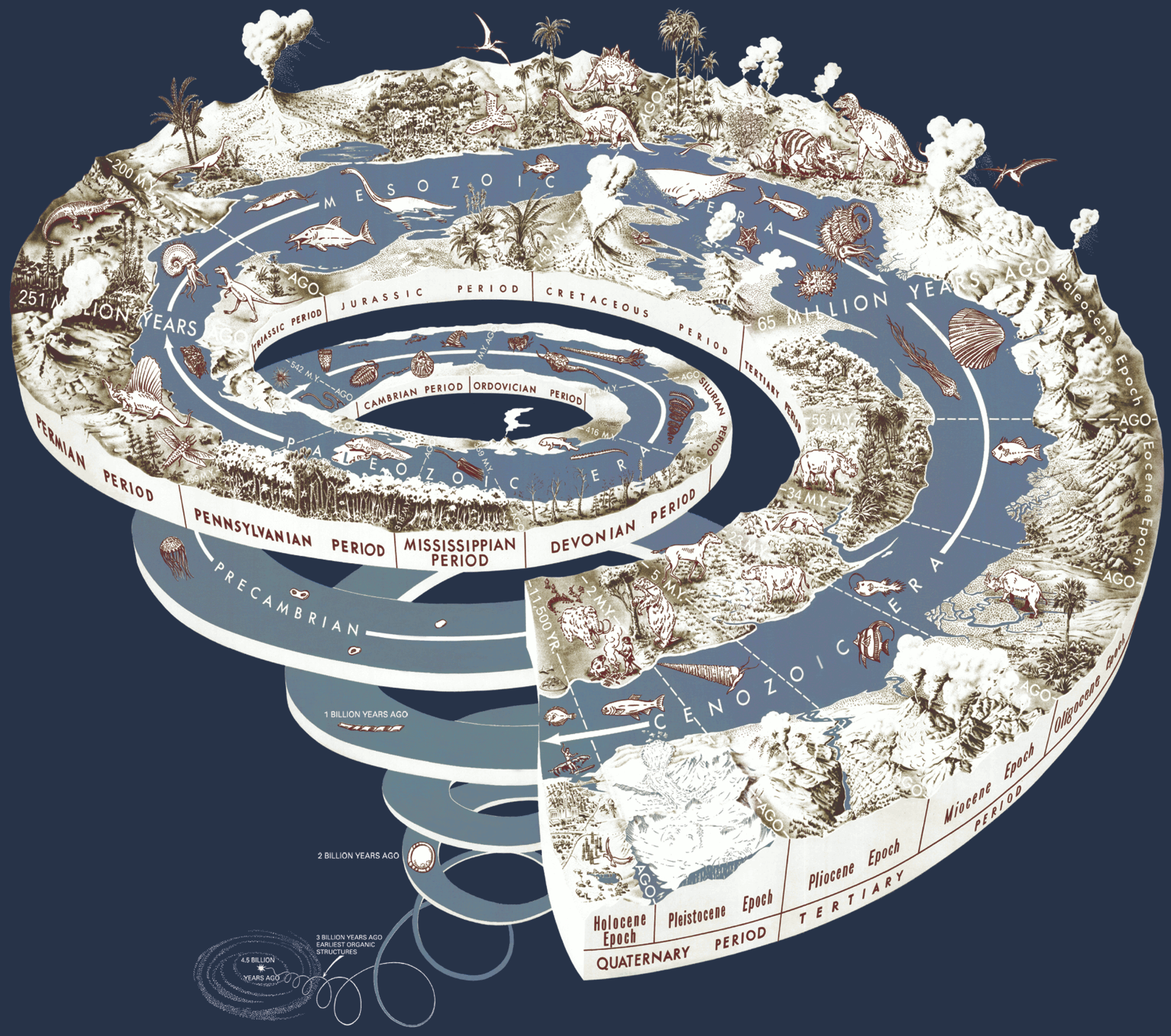
Spiral of Time
Look at this awesome time spiral of earth's history created by the US Geologic Service.

Here's a click through of a much larger version of the image.
I do wonder if the artists who created this were inspired by the helicoid geochronograph in James Gurney's Dinotopia books. In those books, the inhabitants believed that time was neither linear nor circular, but a combination of the two: a spiral. As such, they built a large spiral clock, as well as smaller hand held timepieces, called helicoid geochrongraphs. Artistic coincidence?
Take a look at the pages in question from Dinotopia: a Land Apart from Time below and make the judgment yourself.
Here's a click through of a much larger version of the image.
I do wonder if the artists who created this were inspired by the helicoid geochronograph in James Gurney's Dinotopia
Take a look at the pages in question from Dinotopia: a Land Apart from Time below and make the judgment yourself.
 |
| Page 68, Dinotopia: ALAFT |
 |
| Page 69, Dinotopia: ALAFT |
Father and Son Team Send Up Camera to Film Outer Space
Space officially begins at 100 kilometers (62 miles) above the earth's surface. Getting there has mostly been the business of governments and large corporations, but increasingly private individuals have been getting into the space race inspired by things like the X Prize.
Take the father and son team of Luke and Max Geissbuhler, from Brooklyn, New York. In August they sent aloft a small homemade camera pod equipped with an iPhone and GPS, to allow tracking and recovery, by using a 19-inch weather balloon. The balloon carried the camera pod to an elevation of nearly 30 kilometer (19 miles) before it burst due to pressure differences causing the balloon to expand. The pod parachuted back to earth, landing in a tree a mere 30 miles from its launching point. They didn't quite make it into space, but they made a good effort of it and the video they created from their recorded footage is a great watch.
Take the father and son team of Luke and Max Geissbuhler, from Brooklyn, New York. In August they sent aloft a small homemade camera pod equipped with an iPhone and GPS, to allow tracking and recovery, by using a 19-inch weather balloon. The balloon carried the camera pod to an elevation of nearly 30 kilometer (19 miles) before it burst due to pressure differences causing the balloon to expand. The pod parachuted back to earth, landing in a tree a mere 30 miles from its launching point. They didn't quite make it into space, but they made a good effort of it and the video they created from their recorded footage is a great watch.
Henry Beck, Maps as Art: Revisioning the Tube
For the next two weeks an art exhibition of Dr. Max Roberts will be held in London. Dr Roberts works entail the re-visioning of London's iconic Tube maps: maps as art. Although the maps have been on display elsewhere before, this is their first appearance in London itself. The brochure for the event explains it as such:
So, who was this Henry Beck fellow, and why was his 1933 map so revolutionary? Well, his work fundamentally changed cartography and how we go about depicting information about the world we live in. His map might not look like much, but if you live in a city with a rail or bus system and use it to get around it is likely that you have Beck to thank for finding your way around so much easier.
Since revolutionising map design in 1933, Henry Beck’s iconic map of the London Underground has set the standard for the mapping of transport networks worldwide but is this template always a success?
Dr. Roberts attempts to feminize the Tube by replacing
Beck's straight lines and angles with soft curves.
That is the subject of an exhibition of map designs, by University of Essex researcher Dr Maxwell Roberts. . . .Underground Maps Unravelled: Explorations in Information Design explores the use of Beck’s basic design rules: replacing chaotic, twisting routes with straight lines, horizontal, vertical or diagonals at 45 degrees only. It also looks at whether today’s complex transport networks require fresh approaches.

You can see many of the works on display here.Dr Roberts, of Essex’s Department of Psychology, presents a collection of his own work: maps that break all the rules, maps that are easier to use, maps that teach us about good design, maps that challenge our preconceptions, and maps that are just intended to be decorative.He explained: ‘With today’s emphasis on using public transport, and the ever-increasing complexity of networks around the world, it is vital that designers create the best possible maps. All too often, the general public are faced with designs that are poor quality, off-putting, and perhaps barely useable. We need to take a good look at whether fresh approaches are required.’
So, who was this Henry Beck fellow, and why was his 1933 map so revolutionary? Well, his work fundamentally changed cartography and how we go about depicting information about the world we live in. His map might not look like much, but if you live in a city with a rail or bus system and use it to get around it is likely that you have Beck to thank for finding your way around so much easier.
Friday, October 8, 2010
The History of Miniature Golf

Did Volcanoes Wipe out the Geico Caveman?
 |
| No comment . . . |
About 40,000 years ago in what is now Italy and the Caucasus Mountains straddling Europe and Asia, several volcanoes erupted in quick succession. The researchers argue that these eruptions caused a "volcanic winter" as ash clouds filled the sky, blocking the sun's rays, and that this may have lasted for years. The climatic shift devastated the region's ecosystems.
Evidence for the affect this volcanic winter may have had on neanderthal populations comes from Mezmaiskaya cave in the Caucasus Mountains of southern Russia. The site is rich in Neanderthal bones and artifacts, and recent excavations there have revealed two distinct layers of volcanic ash that coincide those volcanic events.
Analyzing the ash layers led to the discovery that there was a correlation between the thickness of a layer and the amount of pollen it contained; the thicker the layer, the less pollen it had. That's would be a good indicator that there had indeed been a dramatic shift in climate at the site at the time of the eruption and that plant populations had dwindled. The loss of plant forage would have led to a decline in plant-eating animals, and the neanderthals, who depended on large mammals for food, would have been affected. With that in mind, it is noticeable that the Neanderthal's presence at Mezmaiskaya appears to have come to an end following the second eruption as no bones or other neanderthal have been found above the second ash layer.
The idea for environmental factors playing a role in the extinction of the neanderthal is not new, but the research does provide new evidence and a mechanism to explain the cause of an environmental pressure the neanderthal would have experienced. It is not yet perfect as a hypothesis, and the researchers stress the need for further data in other parts of Europe, but their finds at Mezamaiska have provided the important supporting evidences needed for further research.
Sources
Than, Ker. September 22, 2010. Volcanoes Killed Off Neanderthals, Study Suggests.
University of Chicago Press Journals. 8 October 2010. Volcanoes Wiped out Neanderthals, New Study Suggests.
Ajka Alumina Plant Accident
 | |
A reservoir containing red mud of an alumina factory near Ajka, Hungary, dated 24 August 2006. E EPA/Sandor H. Szabo |
Thursday, October 7, 2010
Sinkholes and the Tragedy of a Small Town
 EarthCurrent reader Chill made a comment in my post on water insecurity about how depleting aquifers has led to sinkholes in Florida. As it would happen, Mother Nature Network put up an article with photos of 12 amazing sinkholes.
The photo to the left is one of MNN's 12 sinkholes, and is one sinkhole of many that have formed around the town of Picher, Oklahoma, a place the EPA has called the most toxic place in America.
Trash, Bodies Litter the Slopes of Everest
 |
| A sherpa sorting trash on Everest Photo Credit: Cory Richards |
Nepalis, who view the mountain as a holy site, are also concerned about the number of corpses that have been collecting on the peak. 80 climbers have died on Everest above the two base camps that service both sides of the mountain since 1996. South Base Camp, which is on the Nepal side, rests at 5,360 meters (17,590 ft); North Base Camp, in Tibet, is at 5,545 meters (18,192 ft). Do to the difficulty in removing the bodies, most are left in the spot they died. In May of this year, the bodies of Swiss and Russian climbers were brought down, along with a pair of unidentified arms, though one arm was still wearing a watch.
SOURCE
UPDATE: Thought some of you might like this additional factoid: "Of the 189 people who have died in their attempts [to climb everest], an estimated 120 of them remain there."
SOURCE
UPDATE: Thought some of you might like this additional factoid: "Of the 189 people who have died in their attempts [to climb everest], an estimated 120 of them remain there."
Wednesday, October 6, 2010
Debate Renewed Over Cause of Lusi Mud Volcano
 |
| The village Sidoarjo inundated with mud (picture source) |
A group of Russian scientists has renewed the debate over the cause of the Lusi mud volcano in East Java, Indonesia. While the general scientific consensus has been that the volcano was caused by gas drilling in the area, the Russian team is pointing at earthquakes, which were initially considered but then dismissed, as the true cause of the mud volcano's eruption.
In May of 2006 the East Javan village of Sidoarjo was the victim of a volcano, a volcano that did not erupt lava, but rather scalding hot mud. The volcano has been erupting ever since, expelling nearly 30,000 cubic meters of mud each day, and it is expected that the volcano is capable of a continuing eruption for the next 30 years. Already the volcano has covered about seven square kilometers and about 11 villages, displacing about 40,000 people. A network of levees was constructed in 2008 to try and contain most of the mud, but there is continuing concern about the potential of the levee system failing.
Tuesday, October 5, 2010
Street View Captures Death on the Streets of Brazil
Google Street View came to Brazil allowing armchair exploration of Brazilian cities. While Street View users were expecting to finding images of life on the streets of Brazil many were shocked to find images of death instead.
At least two dead bodies, one from a murder, and another from a reported hit-and-run appeared in Street View. Both have since been removed by Google, but screen caps were grabbed by users of Street View.
WARNING: GRAPHIC IMAGES BEYOND JUMP
At least two dead bodies, one from a murder, and another from a reported hit-and-run appeared in Street View. Both have since been removed by Google, but screen caps were grabbed by users of Street View.
WARNING: GRAPHIC IMAGES BEYOND JUMP
Video: Climbing into a Volcano

Few of us will ever have the chance to peer down into a volcano, and fewer still would dare think of actually climbing down into the crater of one. Especially if the volcano's crater was full of bubbling and churning molten rock. However, that is just what Drew Bristol did, climbing 500 meters down into the crater to a point a mere 100 meters above the lava inside Marum volcano on Ambryn Island in Vanuatu.
Check out the video after the break!
Monday, October 4, 2010
Water Insecurity
BBC News has an article up breaking down a recent article in the journal Nature that discusses the threat to water security around the world, and how attempts to manage water in developing regions threatens biodiversity.
The journal's summary puts it as such:
The journal's summary puts it as such:
We find that nearly 80% of the world’s population is exposed to high levels of threat to water security. Massive investment in water technology enables rich nations to offset high stressor levels without remedying their underlying causes, whereas less wealthy nations remain vulnerable.Essentially, the richer a nation is the better able it is at building and maintaining a water infrastructure to serve all of its citizens than a poor nation can.
Ptolemy's Map Decoded
 |
| (Ptolemy's 150 CE World Map (redrawn in the 15th century). |
The ancient map in question was created in the second century CE by Egyptian astronomer and mathematician Ptolemy who had set out to create a map of the known world. It seems surprising that someone like Ptolemy, living along the Nile as he did, would have had much detailed knowledge of the world beyond the borders of the Roman empire, especially of areas as far away as India and China. But it is likely that he took advantage of the vast network of Roman traders, seafarers, and maps used by Roman legions. Indeed, Rome had contact with Chinese emissaries as early as the second century BCE, so elements of the far east, though vaguely described in his work, would not have been totally unfamiliar. As such, Ptolemy was able to create 26 color maps of the known world, drawn on animal skins, that would come to be contained in his famous treatise on cartography, Geographia.
Saturday, October 2, 2010
Indonesean Volcanoes Primed for Eruption
The Jakarta Globe is reporting that 21 volcanoes across the island nation have their alert statuses at level 2 or above, elevating the potential for even more volcanism. 18 of the volcanoes have had their alert statuses raised from 1, which is classed as "normal" to 2, which is classed as "warning." The remaining three still have statuses sitting at level 3, "standby." All 21 volcanoes have erupted this year.
 Of the level 2 volcanoes, one is Anak Krakatau, a growing remnant of Mount Krakatoa which famously exploded in 1883, all but destroying the island of Krakatoa and killing an estimated 37,000 people (though some estimates put the death toll as high as 120,000 people).
One of the level 3 volcanoes is Mount Sinabung which had been elevated to 4 when it began a series of eruptions on 28 August 2010. It was lowered to level 3 on 23 September, two weeks after experiencing the strongest eruption the volcano had experienced since it first erupted in August.
Mount Karangetang, another of the currently level 3 volcanoes, is one of Indonesia's most active volcanoes having erupted 41 times since 1975. An eruption on 6 August 2010 left little time for evacuation leaving 4 missing and feared dead.
Mount Ibu, the third level 3 volcano, has a lava flow running down its western slope from a parasitic cone.
Friday, October 1, 2010
Google Street View goes to Antarctica
 |
| Google Street View heads due south. |
There aren't many streets on the earth's southern most continent, but that hasn't stopped Google from taking Street View there.
So far there only panormaic views on a small island in the South Shetland Islands off the southern tip of Argentina called Half Moon Island, which has a sizeable rookery of chinstrap penguins. Little surprise, then, that Google has swapped out their little yellow stick figured Pegman, used elsewhere, with a little black and white penguin (Pengman?) (oh, he flops onto his belly to slide around the ice when you click and drag him around the map!).
There are also a lot of static pictures that can be viewed by dragging the penguin onto blue dots.
Subscribe to:
Posts (Atom)